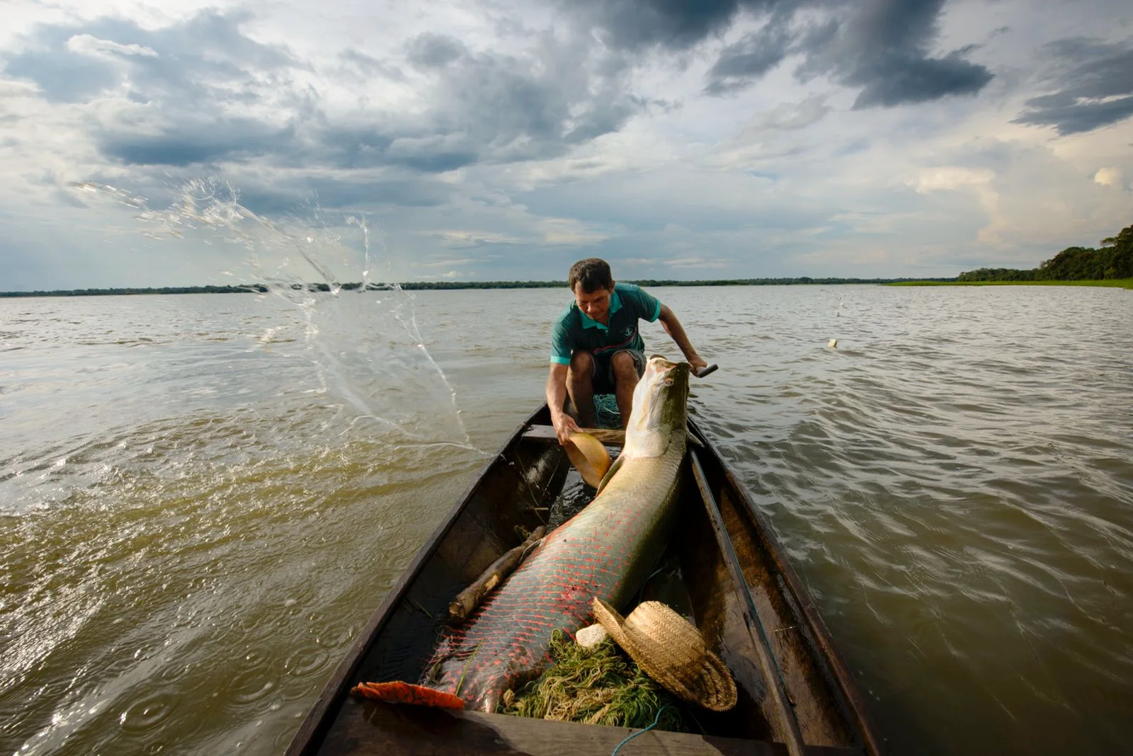
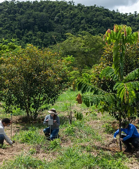
Understand how knowing the Itacaiúnas river basin can help conserve the entire Amazon
Like the rest of the Amazon basin, this region in eastern Pará suffers from the pressures of deforestation and the climate crisis, but with one difference: there is vast scientific research available.
In eastern Pará, near Tocantins, a region the size of Switzerland holds a microcosm that helps explain what is happening throughout the Amazon.
1/9
It is the Itacaiúnas River Hydrographic Basin (BHRI).
2/9
The river begins at the top of Serra da Seringa, in the municipality of Água Azul do Norte, and travels 390 kilometers until reaching its mouth at the Tocantins River, in the city of Marabá.
3/9
The river and its tributaries, such as Parauapebas, the most important one, supply ten municipalities in the region.
4/9
The basin is located in the so-called Amazon Deforestation Arc, the region that concentrates the municipalities with the highest deforestation rates.

5/9
Between 1985 and 2023, the region lost 51% of its forest area, according to MapBiomas data.

6/9
But the forest and its exuberant biodiversity still resist.
7/9
The Carajás Mosaic brings together six federal conservation units, including the Carajás National Forest, which protect 800,000 hectares of forest.
8/9
In the Xikrin do Rio Cateté and Sororó Indigenous Lands, the knowledge of indigenous peoples contributes to the conservation of another 477,000 hectares of vegetation.
9/9
Why is it important to tell this story?
Studying the Itacaiúnas river basin means understanding the impacts suffered by the entire Amazon. The region is marked by conflicts between predatory exploitation and biodiversity conservation. The science conducted there can point the way to protecting Brazil's largest biome.
Partnerships and collaborations
ITV's research in Itacaiúnas is supported by the Emílio Goeldi Museum of Pará, the Rio de Janeiro Botanical Garden, the Amazon Environmental Research Institute, the National Center for Cave Research and Conservation of ICMBio, the Geological Survey of Brazil/Mineral Resources Research Company, the Federal University of Pará, and the Federal University of Alagoas, among others.
Mata N’Ativa Glossary
We work for access to scientific knowledge. Be sure to explore the glossary at the end of the story to get a clearer understanding of each of the concepts covered in the text!
Access Glossary
Observing satellite images of the Itacaiúnas river basin, in southeastern Pará, over the last few decades is like seeing a miniature portrait of the entire Amazon. With an approximate area of 41,300 km² – almost the size of Switzerland – its natural landscapes have been severely impacted by different human activities.
The basin is located in the Arc of Deforestation, which, like the rest of the Amazon, began to advance from east to west and from south to north, starting from the Cerrado. There, the devastation is met with barriers in indigenous lands (TIs) and conservation units (UCs), such as the Carajás National Forest (Tapirapé-Aquiri), established in 1998.
There is, however, a fundamental difference in this Amazonian microcosm: there is a lot of scientific data available. Researchers have been studying the region, and their discoveries may indicate paths for the Amazon as a whole.

Born mainly from the confluence of two rivers in the Serra da Seringa, in the municipality of Água Azul do Norte, in southeastern Pará, the Itacaiúnas River flows north, crosses the Carajás Mosaic, and empties into the left bank of the Tocantins River, near the city of Marabá. PHOTO: João Marcos Rosa
From Coudreau to the 21st century
The Carajás region, in the Itacaiúnas river basin, gained prominence in the 1960s with the discovery of one of the largest iron reserves in the world. The basin, however, was occupied long before. In the book 'Voyage to Itaboca and Itacaiúnas,' by the French explorer Henri Coudreau, from 1887, there is a mention of local indigenous communities, such as the Xikrin do Cateté, who still occupy part of the basin's territory today. The author also describes precarious dwellings along the riverbanks, with non-indigenous residents. Coudreau estimated that the region had been occupied by outsiders for just over a year.
The work was written after an expedition led by the explorer for geographical reconnaissance of the territory. Stretches of the rivers are described, such as the Itacaiúnas, which has its mouth in the municipality of Marabá, and the Parauapebas, one of its main tributaries. A curious observation by Coudreau is that the residents did not seem to practice agriculture, which indicated a dependence on the natural heritage of the forest and rivers.
In the 21st century, the scene is very different. Small communities and villages have given way to cities that maintain a rural character but offer urban infrastructure. “When I arrived here, the main avenue was a dirt road, the bus station was very small, surrounded by wooden shacks that were the shops,” recalls environmental engineer David Santos, who 15 years ago left the state of Minas Gerais to live in the municipality of Ourilândia do Norte, where he works with water resources management in the Itacaiúnas river basin. “Today, everything has LED lighting, the bus station is in a large, beautiful building. It has changed a lot,” he comments.
Just as in the urban centers, the rural landscape has also changed: cattle ranching has become part of the landscape and an important economic activity for the region, as has mining.
Among the reasons for the urbanization and major changes in the territory of the Itacaiúnas river basin are the construction of roads, incentives for occupation and deforestation during the dictatorship period, and, from the 1980s onwards, mining activities. “The division and creation of new municipalities were forced by political-administrative issues, precisely for the management of the territory,” explains Rosa Paes, an agronomist and researcher at the Vale Institute of Technology (ITV). The local municipalities are, for the most part, between 30 and 40 years old.
On his journey along the Itacaiúnas and Parauapebas Rivers in the late 19th century, French explorer Henri Coudreau documented the presence of indigenous peoples and small riverside communities.
1/9
And he described how the people of the region didn't seem to grow crops: they lived off the forest and its rivers.
2/9
Today, many of the villages and communities have been replaced by cities.
3/9
From the 1970s on, with the dictatorship's campaign to integrate the Amazon region with roads such as the Transamazônica (BR-230) and Belém-Brasília (BR-010) interstates, the region began to receive greater numbers of migrants.
4/9
This led to rapid urbanization and deforestation of part of the basin. The mining of Serra Pelada, which attracted over 100,000 people in the 1980s, accelerated this process.
5/9
In the area now protected as the Carajás National Forest (Flona)...
6/9
Vale and the federal Grande Carajás project began geological research even earlier, starting with the discovery of the first high-grade iron deposits in 1967.
7/9
In 1985, the first mine, N4E, began operations...
8/9
as did the Carajás railroad, which transported the ore to São Luís, in Maranhão.
9/9
Serra Pelada, illegal mining, and mining
In the last decades of the 20th century, the migration of people from all over Brazil in search of opportunities in gold mining was very intense. “Serra Pelada brought a lot of people. Here they call them adventurers, those people who came with a dream without ever having worked in garimpo and ended up staying,” comments Santos.
Located where the municipality of Curionópolis is today, the largest open-pit mine in the world generated serious socioeconomic and environmental consequences for the Carajás region. And illegal mining is still a relevant gear in the local economy. “It's an activity that has been 'modernized,' it's no longer done artisanally, it involves heavy machinery, like trucks, tractors, and dynamite,” says geologist Gabriel Salomão, a researcher at ITV. “It's a predatory activity that doesn't respect environmental rules and has very strong financial bases.”
According to data from MapBiomas in 2022, the Amazon concentrates 92% of the country's mining areas. The main interest of miners is in gold exploration: 85.4% of the mined territory in Brazil is to extract this metal. In recent years, the growth of illegal mining has occurred mainly due to the actions of invaders in Indigenous Lands and Conservation Units. The survey indicates that 39% of the mined area in Brazil was within protected areas in 2022.
According to Salomão, the irregular activity of mineral exploration has been growing exponentially. “The region of Curionópolis, one of the cities in the basin, has a lot of manganese and gold mining. And there are other regions that also started to have mines, such as near the city of Canaã dos Carajás,” comments the geologist. “These are lands full of holes; when you look at satellite images, they look like a lunar landscape.”
The advance of mining harms water quality and generates environmental problems, according to Salomão and other experts. In recent years, the geologist and his team have been dedicated to monitoring the water quality of the Itacaiúnas river basin. The researchers observed that where there is mining, there are high concentrations of potentially toxic metals and a worsening of the river water quality. One of the main problems caused by the rampant exploration of illegal mining is mercury contamination. “While mining activity increases, water quality only decreases and, at some point, the bill comes to the region's inhabitants,” says the researcher.
A portion of Vale's environmental activities in the mosaic corresponds to counterparts required by law for mineral exploration – such as the creation of the Campos Ferruginosos National Park. The predominant fraction of investments, however, is voluntary. According to Vale, between 2009 and 2020, the financial contribution was R$ 1 billion, of which R$ 910 million were not mandatory.
Among the voluntary activities are the recovery of 100,000 hectares of forests and the protection of 400,000 hectares beyond the company's borders. Other actions include environmental monitoring, biodiversity conservation, environmental education, technical and financial support for the bioeconomy, and scientific research through ITV.
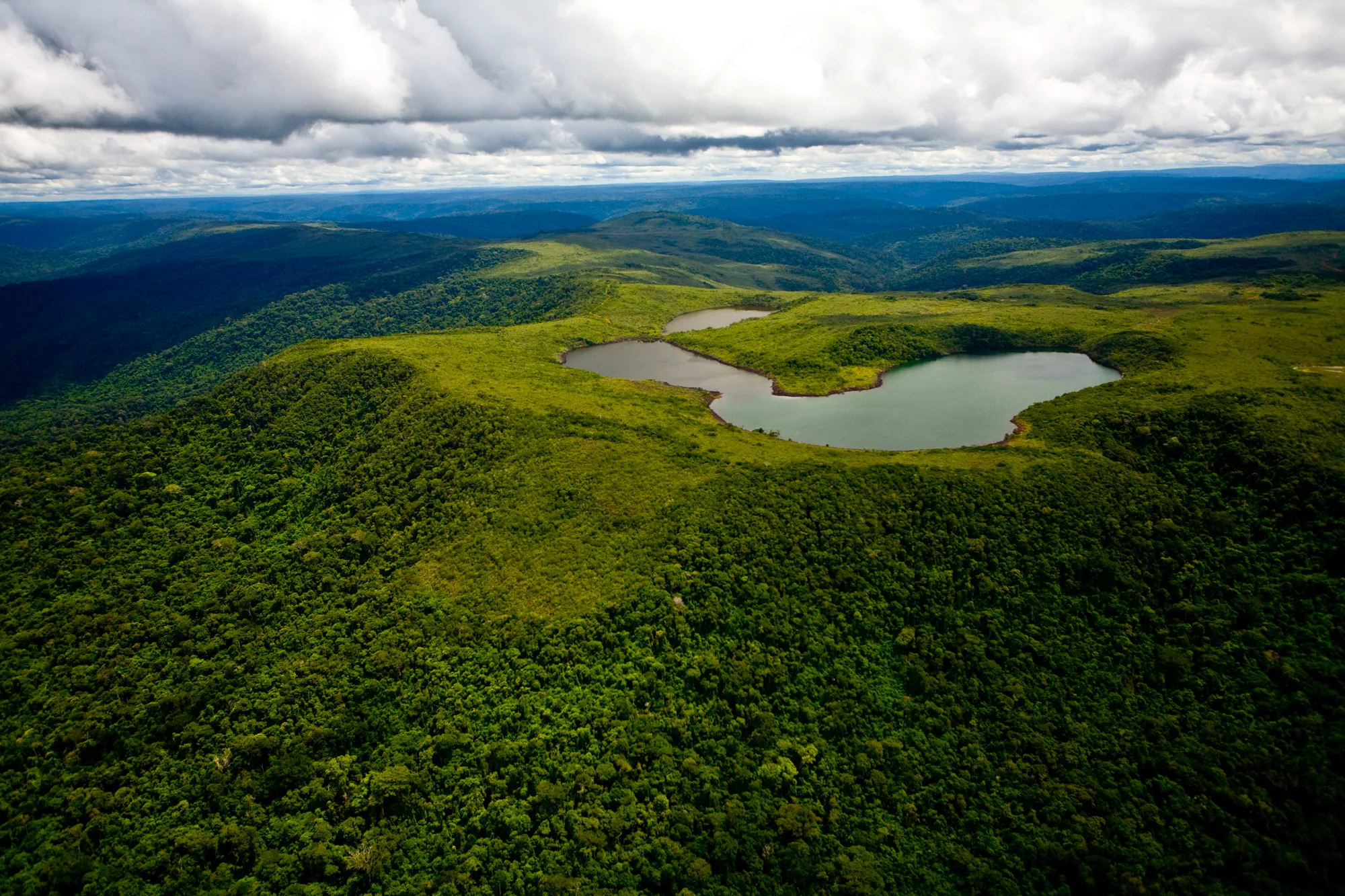
The Lagoa das Três Irmãs, located in the Campos Ferruginosos National Park, is one of the many lagoons formed by rainwater on the top of the Serra Sul de Carajás. PHOTO: João Marcos Rosa
Segundo dados do MapBiomas de 2022, a Amazônia concentra 92% das áreas de garimpo do país.
O principal interesse dos garimpeiros está na exploração de ouro:
Nos últimos anos, o crescimento do garimpo ilegal ocorreu, principalmente, por ação de invasores em terras indígenas (TIs) e unidades de conservação (UCs).
For the regional superintendent of the Geological Survey of Brazil (SGB) in Belém, Homero Reis de Melo Jr., it is necessary to differentiate illegal mining from mining activity. “Mining companies play a fundamental role in Brazil,” says the geologist. “And, unlike illegal mining, it is a regulated and supervised activity, with very strict legislation.”
In the Itacaiúnas river basin, there have been mining companies since the mid-20th century. Vale has been developing activities in the Carajás Mosaic since the 1980s. In 2024, it produced 328 million tons of iron. Currently, the company's operations occupy 3% of the mosaic, which is formed by six environmental conservation units managed by the Chico Mendes Institute for Biodiversity Conservation (ICMBio) with the company's support.
Iron is the main ore extracted by companies in the area, but there is also exploration of nickel, copper, gold, and manganese. For a long time, the state of Minas Gerais stood out for its large ore reserves, but the Amazon region has gained increasing relevance for the business.
Over the decades, however, reports of water contamination due to metal exploration in the Amazon have increased. “This is a very rich area in the periodic table as a whole, almost the entire territory has high concentrations of everything,” says geologist Gabriel Salomão.

A tapir (of the species Tapirus terrestris) crosses the Itacaiúnas river in the Tapirapé-Aquiri National Forest. At least 44 species of medium or large mammals have been recorded in the Carajás Mosaic. PHOTO: João Marcos Rosa
In 2023, Salomão published an article in partnership with scientists from the Federal University of Pará (UFPA), the Federal University of Amazonas (UFAM), the Geological Survey of Brazil (SGB-CPRM), and the Central University of Punjab, in India, pointing out that between 2017 and 2022, the water quality in the Itacaiúnas river basin worsened significantly. To differentiate what is natural to the Amazonian rocks and soil from what has emerged as a consequence of mineral exploration, he and his research group investigated the geochemical signatures – a kind of fingerprint – of the elements in the Amazonian territory and analyzed satellite images.
Among the chemical elements recorded above acceptable limits are manganese, aluminum, barium, lead, iron, copper, cobalt, chromium, nickel, vanadium, and zinc. According to the research, the main cause for this impact on water quality is the growth of mining in the region. Satellite images showed a growth of 1,500 hectares (2,883%) in the scars left by mining, an area equivalent to 2,100 soccer fields, between 2017 and 2021.
According to José Oswaldo Siqueira, former Scientific Director of ITV Sustainable Development, mining operates with criteria, technology, and rigor to avoid environmental tragedies, especially after the accidents in Mariana (MG) in 2015 and Brumadinho (MG) in 2019. “These accidents raised an alert that we needed to better understand the Itacaiúnas river basin to prevent it from happening there,” says Siqueira. “There is always an impact from the [mining] activity, but it was the mining itself that also helped protect the forest.”

Amphibian (of the species Dendropsophus gr. microcephalus) in the Tapirapé-Aquiri National Forest. At least 68 species of amphibians have been recorded in the Carajás Mosaic. PHOTO: João Marcos Rosa
A window to the future of the Amazon
“When you fly over the Carajás region, you see from the airplane window a vast expanse of protected forest on one side and a very large deforested area on the other,” says Salomão. “A little over half of the Itacaiúnas basin is pasture today,” he states. There, 50% of the forest has been felled in recent decades. “If it weren't for the conservation units, like the Tapirapé-Aquiri of Carajás, deforestation would probably be much greater.”
Since 1985, more than 90% of the deforested areas in the Amazon have become pasture, according to a MapBiomas survey. All this vegetation suppression has a great impact on the basin and is a consequence of a predatory process that prevails in various parts of the Amazon, according to Siqueira.
Due to its location in the Arc of Deforestation, the complex of protected areas of which the Tapirapé-Aquiri of Carajás is a part has great relevance from the point of view of biodiversity conservation. However, due to deforestation, these protected areas are isolated, which hinders the movement of species in search of food, sexual partners, or more climatically suitable areas. Therefore, considering the construction of connectivity areas, or ecological corridors, is important. Two studies of this type were conducted at ITV. One of them, published in 2021, sought to identify these corridors to the west, aiming to connect Carajás to the Terra do Meio complex of protected areas. The other, published in 2022, identified areas to the east, within the Itacaiúnas river basin. Both considered, in fact, climate change, identifying current and future climatically suitable areas in order to protect species from this impact.
To get an idea of the importance of biodiversity in the Tapirapé-Aquiri of Carajás, 646 species of birds have been recorded, making this the richest region in Brazil for birds and one of the most diverse in the world. There are also records of 53 species of butterflies and 122 species of bees. These three groups are important for the pollination process and seed dispersal of the local flora. An ITV study concluded that the state of Pará benefits by almost R$ 5.6 billion per year from pollination services, about a third of its total agricultural production. Among the bees are the stingless meliponines, such as those that pollinate the açaí and produce a type of local honey, açaí honey, unique in the world.
In the region of cangas, a type of vegetation typical of the Serra dos Carajás, there are 38 unique plant species. “It is a very particular environment, we did not know everything about this flora. Throughout the Flora of the Canga de Carajás project, more than 80 taxonomists described all the species, which represent 15% of all the flora studied in the state of Pará,” comments geologist Josiane Martins, manager of research and development projects at ITV.
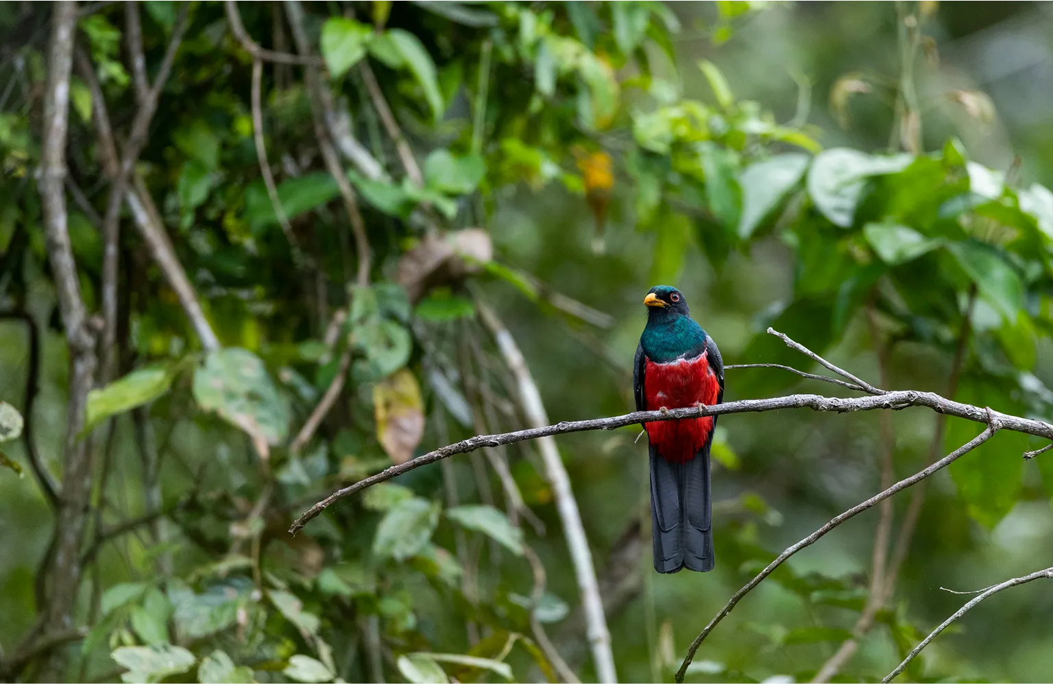
Collared Trogon (of the species Trogon collaris) in the Tapirapé-Aquiri National Forest. PHOTO: João Marcos Rosa
Martins also highlights the species of bats and invertebrates that live in caves in the region and are being mapped by the institute. “This is a little-studied fauna with rare specialized taxonomists. These studies are references both in the discovery of species and understanding of their ecology, and in the innovation of the methodology used, environmental genomics. The sequenced DNA, associated with taxonomic knowledge, helps to determine whether a species is new or not,” she explains.
Another exclusivity of the basin is jaborandi, a plant of great value to the pharmaceutical and cosmetic industries. The species was discovered by the local native peoples and used as medicine. Today it is known to be the only natural source of pilocarpine (a substance used in the treatment of eye diseases, such as glaucoma) in the world.
The plant is very important for local communities, which have the collection of jaborandi as one of their main sources of income. ITV contributes to the activity through research and management actions. “It is socioeconomically important, many populations there sustainably exploit jaborandi, but they are being greatly affected by climate change,” points out biologist Rafael de Fraga, a biodiversity researcher at the institute.
Analyses of historical series indicate both longer and more severe droughts and an increase of 0.6°C, between 1991 and 2020, in the average temperature in the basin. “It may seem like a small increase, but for plants to be able to photosynthesize and carry out a whole set of chemical reactions, it is already a lot, because temperature affects the biological function of the proteins necessary for photosynthesis,” says Fraga.
According to the specialist, the whole process is self-reinforcing: “The increase in heat and the loss of moisture, of primary productivity and of biomass, due to deforestation and fires, all this hinders the natural regeneration of the forest and, obviously, has a very large social impact," he says. “Especially in the most fragile communities that depend on the extraction of forest products or hunting. These are people who maintain an ancestral lifestyle, who depend on the health of ecosystems.”
The territory already faces challenges with the monsoon climate characteristic of the region, with a long period of intense rain and a drastic dry season. “About 95% of the rains occur between December and April or May,” says Paulo Pontes, a civil engineer and researcher at ITV. “It is a basin that lies on the border between the Amazon biome and the Cerrado, so it has its peculiarities, which we can call the paradox of the Amazon: a very rich and abundant region in water, but which can face intense droughts.” The periods without rain can exceed 30 days.
With the advances of both the climate crisis and deforestation, the situation tends to worsen not only in the Itacaiúnas region, but also throughout the Amazon biome. For many of the specialists, the basin can be considered a microcosm of the biome and understanding it in depth is a way to find paths. “The current scenario of the Itacaiúnas river basin is a reflection of what the Amazon basin may face with half of its territory already deforested. The basin anticipates, on a smaller scale, the future of the Amazon if there is no urgent reinforcement in protection policies,” evaluates Pontes.
GLOSSARY
Arc of Deforestation
a region where the agricultural frontier is advancing, stretching from western Maranhão and southern Pará westward, passing through Mato Grosso, Rondônia, and Acre; the highest rates of deforestation in the Amazon are concentrated in this arc
Serra Pelada
a region located in the Serra dos Carajás, in Pará, known for having housed the world's largest open-pit gold mine, which peaked between 1980 and 1983, attracting more than 100,000 miners in search of gold
Garimpo (Artisanal Mining)
areas for the extraction of valuable gems, metallic or non-metallic minerals. It is considered illegal when it does not have the proper authorizations. It was seen as an artisanal activity, but criminal mining has been carried out on a large scale in the Amazon, with the support of expensive machinery and infrastructure
Mining
an economic and industrial activity that includes the research, exploration (extraction), and processing of ores present in the soil and subsoil; it depends on authorizations, concessions, and licensing, among others
Geochemical signature of elements
allows scientists to identify the origin of a material, because a specific combination of chemical elements can function as a 'fingerprint' of a rock, soil, water, or mineral deposit
Cangas
plant ecosystems associated with places where ferruginous rock outcrops occur. Also known as ferruginous fields, they harbor very specific living beings adapted to the characteristics of this vegetation
Primary productivity
the amount of energy (or biomass) produced by autotrophic organisms—such as plants, algae, and cyanobacteria—through photosynthesis
Biomass
the total amount of organic matter present in the living beings of an ecosystem