Less Forest, More Heat: Deforestation Changes Climate in Carajás
Global warming and deforestation affect the climate of the Itacaiúnas river basin. Restoring forests in priority areas can mitigate the problem.
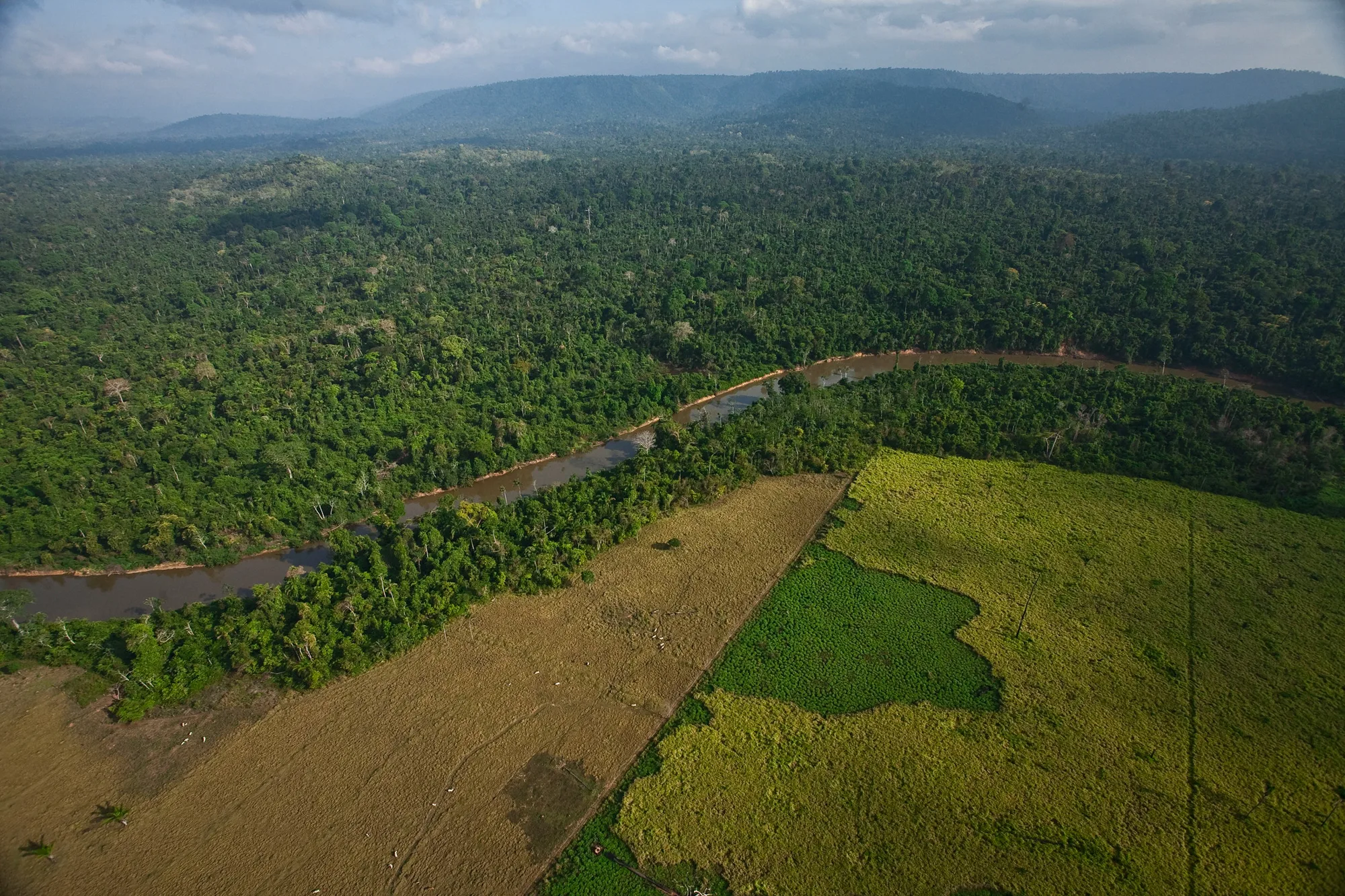
The Carajás National Forest, a conservation unit in the Itacaiúnas river basin, borders a deforested area used for pasture. PHOTO: João Marcos Rosa
Why is it important to tell this story?
The Itacaiúnas river basin is considered a microcosm of the eastern Amazon in terms of threats and resilience. The vast scientific research conducted there could indicate ways to curb the impacts of climate change on the entire biome.
Partnerships and collaborations
The Vale Institute of Technology's (ITV) research on regional climate modeling and experiments in replacing forest with pasture was carried out in partnership with the Federal University of Pará (UFPA).
Mata N’Ativa Glossary
We work for access to scientific knowledge. Be sure to explore the glossary at the end of the story to get a clearer understanding of each of the concepts covered in the text!
Access Glossary
“The heat has increased, the rains are more scattered, winter is no longer the same.” This is how beekeeper and agricultural technician Hernanes Martins, a resident of the municipality of Canaã dos Carajás, has been assimilating the changes in the climate and water cycle in the Itacaiúnas River Basin (BHRI), an area of about 42,000 km² in southeastern Pará.
Hernanes is right in his perception. Comparing the period from 1991 to 2020 with 1961 to 1990, researchers from the Vale Institute of Technology (ITV) concluded that the basin has indeed become hotter and drier in recent decades. The average annual temperature has risen throughout the basin, as has the average for the rainy (November to April) and dry (May to October) seasons. In the eastern part and in some areas to the west, the increase reached 0.6ºC.
When we compare two consecutive climatological periods, from 1991 to 2020 with 1961 to 1990, the annual rainfall volume decreased throughout the basin, especially in the Carajás National Forest. This region had a reduction in its average monthly rainfall of more than 15 mm. Today, in the 1991-2020 period, both the rainy seasons are less rainy and the dry seasons are even drier.
“The future is uncertain, but if it continues as it is, the impacts we are already feeling will probably be intensified,” points out Cláudia Wanzeler, PhD in climate and environment, a researcher at ITV and co-author of the research.
Part of this phenomenon is explained by the climate emergency and the increase in global temperature. But there is another important factor: changes in land use. The conversion of forest areas into pastures, for example, can influence the local climate, the regional climate, and, in the long term, the global climate.
Deforestation in the Itacaiúnas river basin reduced the forest cover from 95% to 51% of the territory in just 36 years (1980-2016). This process was driven by the national policy of Amazon occupation, which included the construction of roads like the Trans-Amazonian Highway, the creation of rural settlements, and the arrival of migrants attracted by the gold rush at the Serra Pelada mine. All of this was decisive for the transformations in vegetation cover and had direct effects on the region's hydroclimatology.
Those who live in the Itacaiúnas river basin, like beekeeper Hernanes Martins, know well the new climate reality of the region: "The heat has increased, the rains are more scattered, and winter is not the same anymore".
1/7
ITV researchers confirmed this change by comparing surface temperature data from two 30-year periods: from 1961 to 1990 and from 1991 to 2020.
2/7
The result: the entire basin got warmer. This applies to the annual average temperature...
3/7
the average temperature during the rainy season...
4/7
and the average temperature during the dry season.
5/7
In some parts of the basin, the increase exceeded 0.6ºC. In the annual average, the temperature increased more in the eastern part, historically more deforested.
6/7
But when considering only the average in the dry season, stretches of preserved forest in the western part also suffered with an increase above 0.6ºC.
7/7
DIFFERENCE IN
AVERAGE TEMPERATURE
1961–1990 / 1991–2020

Since 2004, the land use scenario in the basin has been composed of a massive presence of primary forest in the protected areas in the center-west, and pastures, agriculture, and urbanization in the other locations, with some blocks of primary and secondary forest. A large part of the eastern region of the basin has been converted into pastures.
The Itacaiúnas river basin is located in the so-called arc of deforestation of the Amazon, a part of the territory that concentrates the worst rates of deforestation and extends from Maranhão and southern Pará westward, passing through Mato Grosso, Rondônia, and Acre.
“This process advanced more rapidly until 2010. After that, there was a slowdown in deforestation, but we continue to lose forest,” explains Dr. Rosane Cavalcante, an ITV researcher in forest, water, and carbon.
The situation could be worse if not for the preserved forests in the Carajás Mosaic, an area of about 12,000 km² formed by six federal conservation units, including the Carajás National Forest (Flona), and the Xikrin do Cateté Indigenous Land.
To understand the importance of the forest for climate regulation, ITV researchers conducted a series of simulations on how air temperature and precipitation patterns could be altered if the mosaic region had suffered the same fate as other regions of the BHRI. The researchers conducted experiments with computational models that simulated how the replacement of preserved forest in the mosaic with pastures could affect the climate throughout the basin. The result shows a completely different scenario in the distribution of rainfall in the basin and an increase of at least 0.3ºC in temperature without the Carajás Flona or the other conservation units.
The effect would be even more pronounced during the dry season, with an increase in temperature over a large part of the basin. “The results reinforce the importance of protecting the forest and recovering degraded areas,” points out Cláudia Wanzeler.
1/9
2/9
3/9
4/9
5/9
6/9
7/9
8/9
9/9


Water balance
Taller vegetation, like a forest, intercepts a larger volume of rain in the tree canopy and absorbs water from deeper soil depths through its roots. On the other hand, a pasture area has a lower capacity to intercept water.
It is to be expected, therefore, that in a basin where the forest has been replaced by pasture, the tendency is for a reduction in the water that returns to the atmosphere directly through evapotranspiration, when water is transferred from the soil and plants to the atmosphere as vapor.
In the BHRI, seasonality is very well defined: 95% of the rains occur in the rainy season, while 5% of the precipitation happens in the dry season. The river flow follows the same trend: very high in the rainy period and low in the dry season.
But the loss of about half of the forest cover has caused an increase in the minimum, average, and maximum flows in the region's rivers – that is, in the volume of water in the rivers. The models indicate that from 1980 to 2016, the average flow at the mouth of the Itacaiúnas River, at the confluence with the Tocantins, increased by 14% due to deforestation. However, the increase carries negative effects, such as more frequent and intense riverine floods. Without the forest to intercept rainwater via leaves and trunks, absorb it through the roots, and return part of it to the atmosphere, the tendency is for the rivers to overflow.
The increase in flow changes the pattern and quality of the rivers, in addition to affecting local biodiversity. The interception of water by the tree canopy also protects the soil from the direct impact of raindrops, helping to prevent erosion processes.
A researcher at ITV, hydrologist and civil engineer Paulo Pontes, points out that with climate change, the prognosis for the coming years in the BHRI is a reduction in water availability, an increase in river flood flow, and an extension of the time and intensity of the dry period. “It is not a prediction, it is a scenario. The water models indicate to us that this more critical situation could occur in the west of the basin, where the protected areas are located,” he explains.
Finally, the forest cover on the banks and surroundings of the rivers, called riparian forest, is crucial for their protection. The tree canopies cover the riverbeds, balance the water temperature, and help reduce the load of harmful substances that reach the watercourse.
“Many strategic areas that, by law, should be preserved, are not, even in conservation units, legal reserves, and permanent preservation areas,” emphasizes Rosane Cavalcante. Thus, enforcing environmental legislation is non-negotiable so that the deforestation scenario does not worsen.

“The future is uncertain, but if it continues as it is, the impacts we are already feeling will probably be intensified”
Cláudia Wanzeler, ITV researcher
Evapotranspiration
The forest tends to capture more energy and release more water vapor into the atmosphere compared to pasture areas. With more vapor in the atmosphere, there is more humidity and cloud formation, and consequently, greater rainfall production.
In the Carajás Mosaic, about 15 km³ of water per year is transferred to the atmosphere via evapotranspiration. For comparison, the Itacaiúnas River discharges 19 km³ annually at its mouth into the Tocantins. These clouds formed by evapotranspiration in the Amazon can be carried by winds to other parts of the country and the continent, a phenomenon popularly known as “flying rivers.” That is why the water balance is important for climate regulation not only in that region.
Taller forest cover evapotranspires more than a deforested area, if both are in the same condition and with the same amount of water. This is noticeable when comparing the amount of water that returns to the atmosphere in areas within the mosaic with areas outside it. Of all the water that precipitates within the mosaic, 72% (1,277 mm/year) ends up returning to the atmosphere. Outside the mosaic, only 57% of the annual precipitation (1,005/year) returns. Furthermore, in areas outside the mosaic, a greater reduction in total evapotranspiration was observed during the dry period.
But, despite deforestation, evapotranspiration still occurs satisfactorily in the Itacaiúnas river basin, because the water storage below the ground supports evapotranspiration, even in the driest periods. “Even with deforestation, there is still infiltration feeding water into the soil and, consequently, supporting evapotranspiration. This gives us an idea of the basin's resilience to anthropic processes,” comments Paulo Pontes.
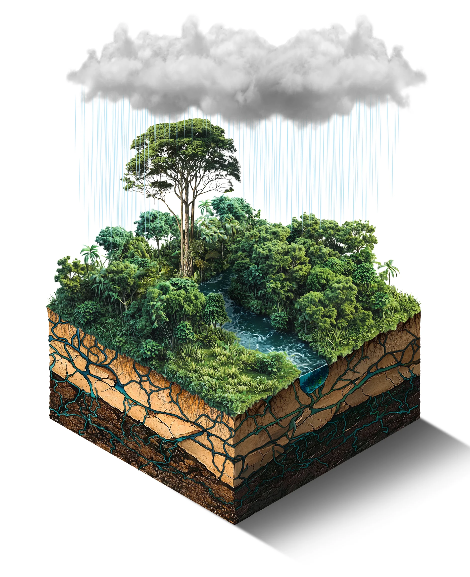
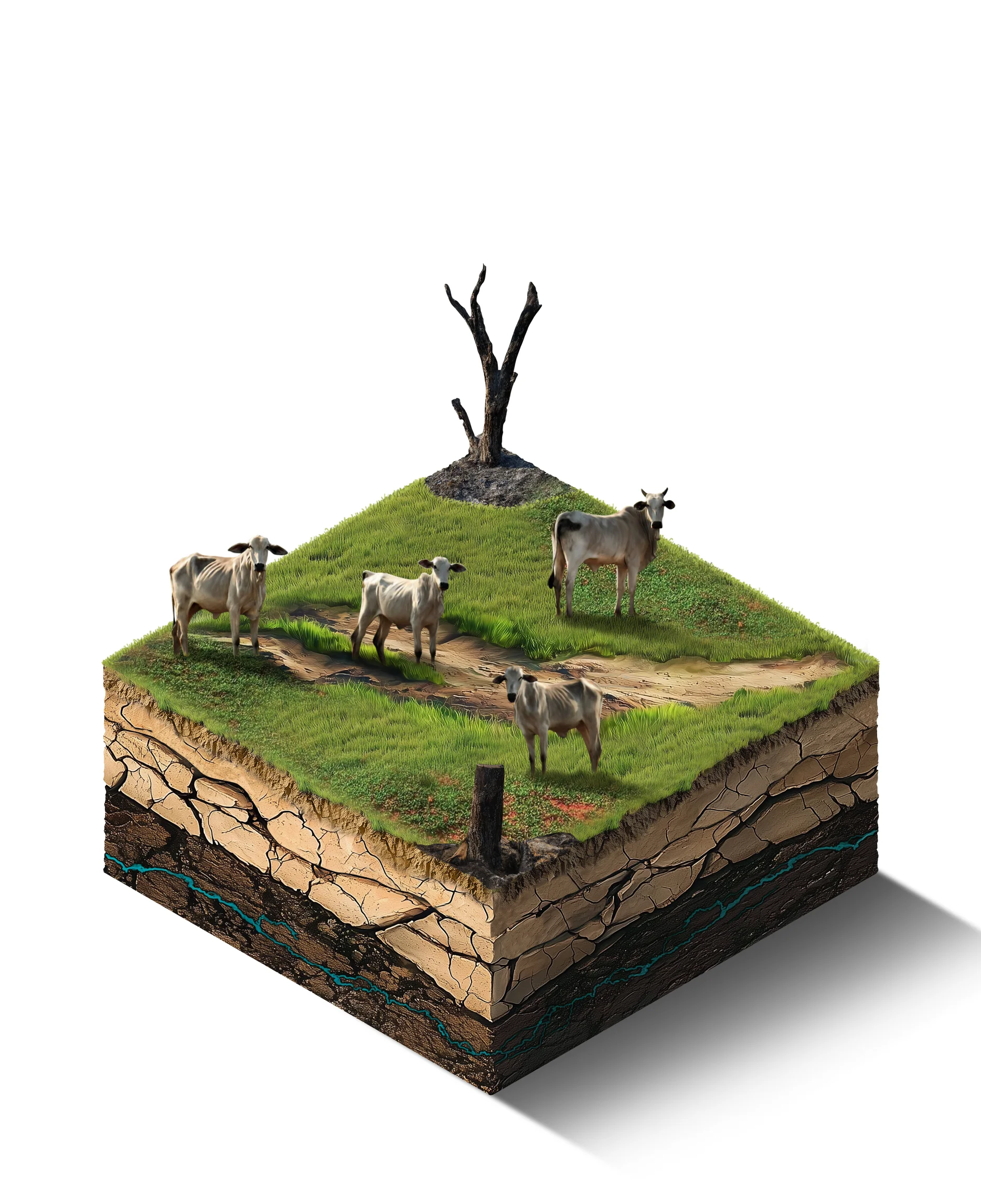
As observed elsewhere, studies in the Itacaiúnas River Basin show that forest areas have higher evapotranspiration and lower surface runoff than pasture areas. The forests of the Carajás mosaic release about 15 km³ of water into the atmosphere annually, vital for the formation of regional rains. ILLUSTRATIONS: Luiz Iria
Adaptation and resilience
Forest regeneration is an essential strategy to ensure the resilience of the Amazon in the face of climate change and environmental degradation. In the Itacaiúnas River Basin, this restoration gains strategic importance, both to recover ecosystem services and to reconnect forest fragments.
“For the restoration to deliver maximum efficiency, proper planting must be done, with spacing, species diversity, application of inputs, and monitoring of plant growth,” explains researcher and agronomist Silvio Ramos, who works on soil quality monitoring at ITV. As the vegetation begins to grow, the soil quality improves, with the carbon stock increasing and generating more nutrients for the plants. Consequently, there is also greater biodiversity in the so-called secondary forests.
To implement mining in certain locations of the BHRI, companies need to suppress the native vegetation cover of the areas that contain ore in the subsoil. To start this process, there are a series of conditions, the main one being the responsibility of the mining company to restore other areas, a form of environmental compensation.
Given this, ITV researchers analyze indicators that help identify priority areas – usually located near preserved forests, such as the Carajás National Forest. “The intention is to buy abandoned farms and rural properties and eliminate these deforested fragments, connecting the acquired areas to the large forest,” details Silvio Ramos.
Thus, mining companies should acquire properties around the mining complexes and transform the abandoned pasture areas into secondary forests, with the planting of seedlings and monitoring of soil quality, reconnecting forest fragments and bringing back biodiversity and ecosystem services.
“Since reforestation has a cost, we did these prioritization studies to know where to start," says Rosane Cavalcante. “For example, the closer to a large area of native forest, the greater the potential for the deforested area to regenerate and return to a forest situation,” she explains.
The fragmentation of the landscape by deforestation has destroyed part of the local fauna's habitat and generated serious environmental problems. In the reforestation process, ITV researchers emphasize the importance of prioritizing the creation of connections between areas so that species can have mobility and not be isolated in restricted points of the forest. These are the so-called ecological corridors. “They promote gene flow, among other functions that help maintain ecological processes,” explains Rosane Cavalcante.
Research shows the importance of reconciling preserved areas and potential restoration areas with larger forest blocks. This is the case for locations west of the Carajás Mosaic. “In a scenario of climate change, the increase in the area of native vegetation needs to guarantee these ‘paths’ for the species, increasing their resilience,” concludes Cavalcante.
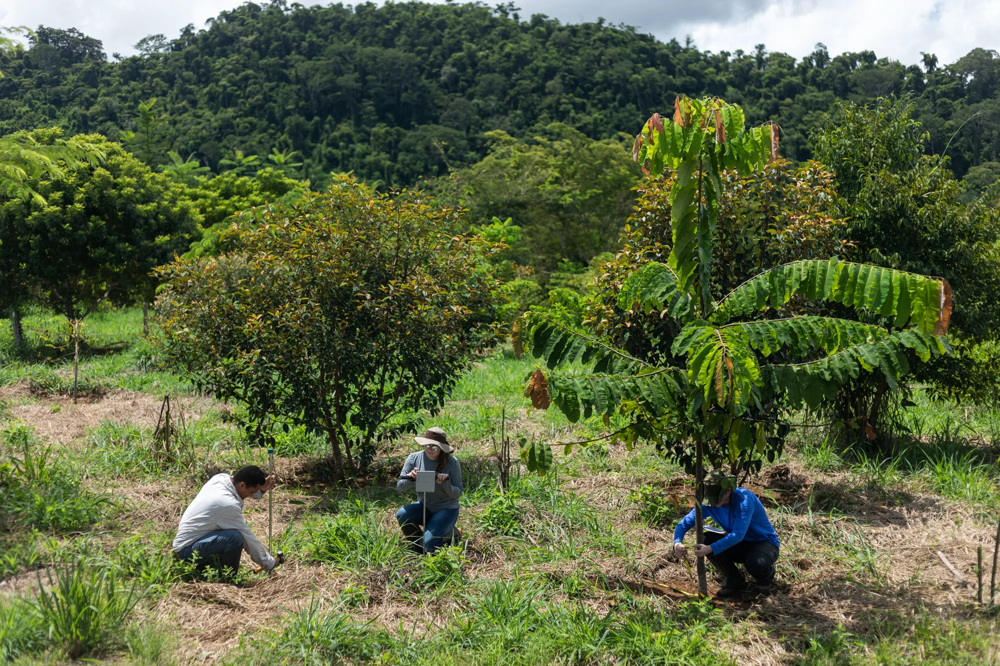
For the processes of environmental compensation and restoration, priority areas are selected, usually on the outskirts of preserved forests, like this one near the Carajás National Forest. PHOTO: João Marcos Rosa
In addition to forest regeneration, another alternative for degraded areas are agroforestry systems (SAFs). Agricultural technician Hernanes Martins, who at the beginning of this story told about the impacts that climate change and deforestation are already causing in the region, was invited by ITV to help implement experimental SAF units in the Itacaiúnas river basin. Over four years, demonstration units were created, combining strategies for reforesting native species with techniques for agricultural production. SAFs are an alternative for deforested areas, where native species of the region are replanted and coexist with banana trees, papaya trees, and bean and corn plants, cultivated for food and commercial purposes.
“Faced with the fight against deforestation and climate change, the SAF is the best alternative to monoculture, as it restores the forest and riparian forests, generates jobs and income, all in a small unit,” defends Martins.
One of the vital properties of forest cover is to assist in adapting to climate change. The standing forest helps to adapt to unusual droughts, for example, because it maintains the hydrological flow.
“Even with reforestation actions, it is not possible to say that the region would return to how it was in the 1970s,” evaluates Cláudia Wanzeler. “But, by increasing the cover, the energy and water balance certainly tends to improve.”
Priority for
restoration

GLOSSARY
Hydroclimatology
a research area that studies the impacts of climate change on water resources through the use of models and remote sensing tools
Minimum, average, and maximum flows
flow is the volume of water that flows through a river in a given time; the minimum is used to assess water availability for irrigation and electricity projects; the long-term average allows for quantifying availability and calculating the regulation volume; the maximum flow is associated with flood conditions and is used in large works
Seasonality
regular and predictable variation of the climate throughout the year
Water balance
the relationship between the water that enters and the water that leaves a system; it is used to measure how much water is available in a certain place and time
Climate regulation
the set of processes that keep the Earth's climate stable and habitable over time; it involves the interaction between the atmosphere, forests, soils, living beings, among others. Factors such as deforestation, pollution, and greenhouse gas emissions lead to imbalance and, consequently, to phenomena such as heat waves, severe droughts, and floods
Secondary forests
they grow in areas where the original vegetation (primary forest) has been deforested, degraded, or disturbed; they offer important environmental services, such as removing carbon from the atmosphere
Carbon stock
the amount of carbon stored in the different components of an ecosystem, such as the forest, soil, or atmosphere
Gene flow
also called migration – is any movement of genes from one population to another